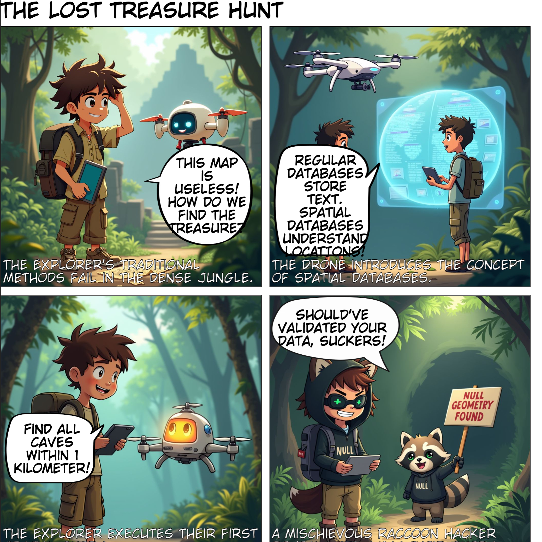
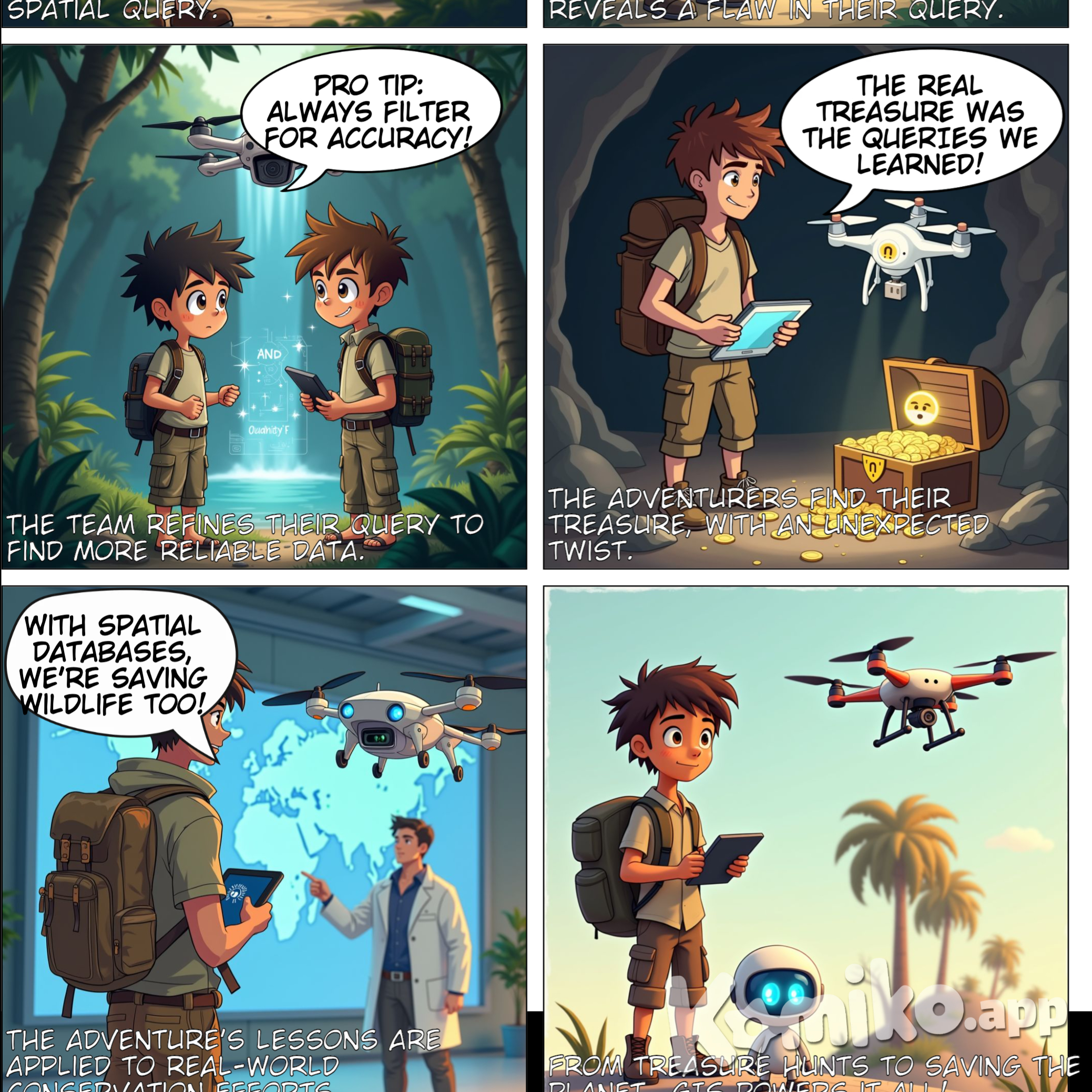
Truyện tranh AI: Title: "The Lost Treasure Hunt: A Spatial Database Adventure" Style: Semi-realistic cartoon (balanced detail + expressiveness) Panel 1: The Lost Explorer Visual Prompt: "A young adventurer (backpack, compass, crumpled paper map) stands in a dense jungle, scratching their head. A high-tech drone with a glowing screen hovers beside them. Vines and ancient ruins in the background." Dialogue: Explorer: "This map is useless! How do we find the treasure now?" Drone: "Paper maps are so 1800s. Let’s ask a SPATIAL DATABASE!" Panel 2: Spatial Database Explained Visual Prompt: "The drone projects a holographic split-screen: Left side shows a boring spreadsheet (rows of numbers). Right side shows an interactive 3D globe with pins, routes, and heatmaps." Dialogue: Drone: "Regular databases store text. Spatial databases understand LOCATIONS—like maps, roads, even volcanoes!" Explorer: "Whoa! So it’s Google Maps on steroids?" Panel 3: The First Query Visual Prompt: "Explorer types on a tablet: ‘SELECT * FROM jungle WHERE feature = ‘cave’ AND distance < 1km’. The drone processes it, and the holographic map highlights a glowing cave icon." Dialogue: Explorer: "Find all caves within 1 kilometer!" Drone: "Executing spatial query... Bingo!" Panel 4: The Villain Strikes Visual Prompt: "They reach a tiny, empty cave. A raccoon in a hacker hoodie giggles, holding a sign: ‘NULL GEOMETRY FOUND’. The drone’s screen shows a red ‘ERROR’ pop-up." Dialogue: Raccoon: "Should’ve validated your data, suckers!" Explorer: "Ugh! Corrupted coordinates!" Panel 5: Debugging the Query Visual Prompt: "The drone and explorer huddle over the tablet, adding ‘AND data_quality = ‘high’’. The map flickers, then reveals a hidden path behind a waterfall (sparkle effects)." Dialogue: Drone: "Pro tip: Always filter for accuracy!" Explorer: "Spatial JOINs for the win!" Panel 6: Treasure Revealed Visual Prompt: "A chest overflows with gold coins and a glowing USB labeled ‘World’s Best GIS Data’. The explorer holds it triumphantly; the drone facepalms." Dialogue: Explorer: "The real treasure was the QUERIES we learned!" Drone: "I hate puns." Panel 7 (Epilogue): Real-World Impact Visual Prompt: "Explorer now wears a lab coat, pointing at a giant screen showing endangered animal tracks on a global map. The drone floats nearby, upgraded with satellite dishes." Dialogue: Explorer: "With spatial databases, we’re saving wildlife too!" Caption: "From treasure hunts to saving the planet—GIS powers it all!"

Tạo bởi bouncy unicorn

Chi tiết nội dung

Thông tin phương tiện

Tương tác người dùng

Về tác phẩm AI này

Mô tả

Gợi ý tạo

Tương tác

bouncy unicorn

bouncy unicorn

Title: "The Lost Treasure Hunt: A Spatial Database Adventure" Style: Semi-realistic cartoon (balanced detail + expressiveness)  Panel 1: The Lost Explorer Visual Prompt: "A young adventurer (backpack, compass, crumpled paper map) stands in a dense jungle, scratching their head. A high-tech drone with a glowing screen hovers beside them. Vines and ancient ruins in the background." Dialogue:  Explorer: "This map is useless! How do we find the treasure now?"  Drone: "Paper maps are so 1800s. Let’s ask a SPATIAL DATABASE!"  Panel 2: Spatial Database Explained Visual Prompt: "The drone projects a holographic split-screen: Left side shows a boring spreadsheet (rows of numbers). Right side shows an interactive 3D globe with pins, routes, and heatmaps." Dialogue:  Drone: "Regular databases store text. Spatial databases understand LOCATIONS—like maps, roads, even volcanoes!"  Explorer: "Whoa! So it’s Google Maps on steroids?"  Panel 3: The First Query Visual Prompt: "Explorer types on a tablet: ‘SELECT * FROM jungle WHERE feature = ‘cave’ AND distance < 1km’. The drone processes it, and the holographic map highlights a glowing cave icon." Dialogue:  Explorer: "Find all caves within 1 kilometer!"  Drone: "Executing spatial query... Bingo!"  Panel 4: The Villain Strikes Visual Prompt: "They reach a tiny, empty cave. A raccoon in a hacker hoodie giggles, holding a sign: ‘NULL GEOMETRY FOUND’. The drone’s screen shows a red ‘ERROR’ pop-up." Dialogue:  Raccoon: "Should’ve validated your data, suckers!"  Explorer: "Ugh! Corrupted coordinates!"  Panel 5: Debugging the Query Visual Prompt: "The drone and explorer huddle over the tablet, adding ‘AND data_quality = ‘high’’. The map flickers, then reveals a hidden path behind a waterfall (sparkle effects)." Dialogue:  Drone: "Pro tip: Always filter for accuracy!"  Explorer: "Spatial JOINs for the win!"  Panel 6: Treasure Revealed Visual Prompt: "A chest overflows with gold coins and a glowing USB labeled ‘World’s Best GIS Data’. The explorer holds it triumphantly; the drone facepalms." Dialogue:  Explorer: "The real treasure was the QUERIES we learned!"  Drone: "I hate puns."  Panel 7 (Epilogue): Real-World Impact Visual Prompt: "Explorer now wears a lab coat, pointing at a giant screen showing endangered animal tracks on a global map. The drone floats nearby, upgraded with satellite dishes." Dialogue:  Explorer: "With spatial databases, we’re saving wildlife too!"  Caption: "From treasure hunts to saving the planet—GIS powers it all!"Title: "The Lost Treasure Hunt: A Spatial Database Adventure" Style: Semi-realistic cartoon (balanced detail + expressiveness)  Panel 1: The Lost Explorer Visual Prompt: "A young adventurer (backpack, compass, crumpled paper map) stands in a dense jungle, scratching their head. A high-tech drone with a glowing screen hovers beside them. Vines and ancient ruins in the background." Dialogue:  Explorer: "This map is useless! How do we find the treasure now?"  Drone: "Paper maps are so 1800s. Let’s ask a SPATIAL DATABASE!"  Panel 2: Spatial Database Explained Visual Prompt: "The drone projects a holographic split-screen: Left side shows a boring spreadsheet (rows of numbers). Right side shows an interactive 3D globe with pins, routes, and heatmaps." Dialogue:  Drone: "Regular databases store text. Spatial databases understand LOCATIONS—like maps, roads, even volcanoes!"  Explorer: "Whoa! So it’s Google Maps on steroids?"  Panel 3: The First Query Visual Prompt: "Explorer types on a tablet: ‘SELECT * FROM jungle WHERE feature = ‘cave’ AND distance < 1km’. The drone processes it, and the holographic map highlights a glowing cave icon." Dialogue:  Explorer: "Find all caves within 1 kilometer!"  Drone: "Executing spatial query... Bingo!"  Panel 4: The Villain Strikes Visual Prompt: "They reach a tiny, empty cave. A raccoon in a hacker hoodie giggles, holding a sign: ‘NULL GEOMETRY FOUND’. The drone’s screen shows a red ‘ERROR’ pop-up." Dialogue:  Raccoon: "Should’ve validated your data, suckers!"  Explorer: "Ugh! Corrupted coordinates!"  Panel 5: Debugging the Query Visual Prompt: "The drone and explorer huddle over the tablet, adding ‘AND data_quality = ‘high’’. The map flickers, then reveals a hidden path behind a waterfall (sparkle effects)." Dialogue:  Drone: "Pro tip: Always filter for accuracy!"  Explorer: "Spatial JOINs for the win!"  Panel 6: Treasure Revealed Visual Prompt: "A chest overflows with gold coins and a glowing USB labeled ‘World’s Best GIS Data’. The explorer holds it triumphantly; the drone facepalms." Dialogue:  Explorer: "The real treasure was the QUERIES we learned!"  Drone: "I hate puns."  Panel 7 (Epilogue): Real-World Impact Visual Prompt: "Explorer now wears a lab coat, pointing at a giant screen showing endangered animal tracks on a global map. The drone floats nearby, upgraded with satellite dishes." Dialogue:  Explorer: "With spatial databases, we’re saving wildlife too!"  Caption: "From treasure hunts to saving the planet—GIS powers it all!"Title: "The Lost Treasure Hunt: A Spatial Database Adventure" Style: Semi-realistic cartoon (balanced detail + expressiveness)  Panel 1: The Lost Explorer Visual Prompt: "A young adventurer (backpack, compass, crumpled paper map) stands in a dense jungle, scratching their head. A high-tech drone with a glowing screen hovers beside them. Vines and ancient ruins in the background." Dialogue:  Explorer: "This map is useless! How do we find the treasure now?"  Drone: "Paper maps are so 1800s. Let’s ask a SPATIAL DATABASE!"  Panel 2: Spatial Database Explained Visual Prompt: "The drone projects a holographic split-screen: Left side shows a boring spreadsheet (rows of numbers). Right side shows an interactive 3D globe with pins, routes, and heatmaps." Dialogue:  Drone: "Regular databases store text. Spatial databases understand LOCATIONS—like maps, roads, even volcanoes!"  Explorer: "Whoa! So it’s Google Maps on steroids?"  Panel 3: The First Query Visual Prompt: "Explorer types on a tablet: ‘SELECT * FROM jungle WHERE feature = ‘cave’ AND distance < 1km’. The drone processes it, and the holographic map highlights a glowing cave icon." Dialogue:  Explorer: "Find all caves within 1 kilometer!"  Drone: "Executing spatial query... Bingo!"  Panel 4: The Villain Strikes Visual Prompt: "They reach a tiny, empty cave. A raccoon in a hacker hoodie giggles, holding a sign: ‘NULL GEOMETRY FOUND’. The drone’s screen shows a red ‘ERROR’ pop-up." Dialogue:  Raccoon: "Should’ve validated your data, suckers!"  Explorer: "Ugh! Corrupted coordinates!"  Panel 5: Debugging the Query Visual Prompt: "The drone and explorer huddle over the tablet, adding ‘AND data_quality = ‘high’’. The map flickers, then reveals a hidden path behind a waterfall (sparkle effects)." Dialogue:  Drone: "Pro tip: Always filter for accuracy!"  Explorer: "Spatial JOINs for the win!"  Panel 6: Treasure Revealed Visual Prompt: "A chest overflows with gold coins and a glowing USB labeled ‘World’s Best GIS Data’. The explorer holds it triumphantly; the drone facepalms." Dialogue:  Explorer: "The real treasure was the QUERIES we learned!"  Drone: "I hate puns."  Panel 7 (Epilogue): Real-World Impact Visual Prompt: "Explorer now wears a lab coat, pointing at a giant screen showing endangered animal tracks on a global map. The drone floats nearby, upgraded with satellite dishes." Dialogue:  Explorer: "With spatial databases, we’re saving wildlife too!"  Caption: "From treasure hunts to saving the planet—GIS powers it all!"
—— Hết ——
Khám phá Xem thêm truyện hoặc bắt đầu tự tạo truyện của bạn!

Title: "The Lost Treasure Hunt: A Spatial Database Adventure" Style: Semi-realistic cartoon (balanced detail + expressiveness) Panel 1: The Lost Explorer Visual Prompt: "A young adventurer (backpack, compass, crumpled paper map) stands in a dense jungle, scratching their head. A high-tech drone with a glowing screen hovers beside them. Vines and ancient ruins in the background." Dialogue: Explorer: "This map is useless! How do we find the treasure now?" Drone: "Paper maps are so 1800s. Let’s ask a SPATIAL DATABASE!" Panel 2: Spatial Database Explained Visual Prompt: "The drone projects a holographic split-screen: Left side shows a boring spreadsheet (rows of numbers). Right side shows an interactive 3D globe with pins, routes, and heatmaps." Dialogue: Drone: "Regular databases store text. Spatial databases understand LOCATIONS—like maps, roads, even volcanoes!" Explorer: "Whoa! So it’s Google Maps on steroids?" Panel 3: The First Query Visual Prompt: "Explorer types on a tablet: ‘SELECT * FROM jungle WHERE feature = ‘cave’ AND distance < 1km’. The drone processes it, and the holographic map highlights a glowing cave icon." Dialogue: Explorer: "Find all caves within 1 kilometer!" Drone: "Executing spatial query... Bingo!" Panel 4: The Villain Strikes Visual Prompt: "They reach a tiny, empty cave. A raccoon in a hacker hoodie giggles, holding a sign: ‘NULL GEOMETRY FOUND’. The drone’s screen shows a red ‘ERROR’ pop-up." Dialogue: Raccoon: "Should’ve validated your data, suckers!" Explorer: "Ugh! Corrupted coordinates!" Panel 5: Debugging the Query Visual Prompt: "The drone and explorer huddle over the tablet, adding ‘AND data_quality = ‘high’’. The map flickers, then reveals a hidden path behind a waterfall (sparkle effects)." Dialogue: Drone: "Pro tip: Always filter for accuracy!" Explorer: "Spatial JOINs for the win!" Panel 6: Treasure Revealed Visual Prompt: "A chest overflows with gold coins and a glowing USB labeled ‘World’s Best GIS Data’. The explorer holds it triumphantly; the drone facepalms." Dialogue: Explorer: "The real treasure was the QUERIES we learned!" Drone: "I hate puns." Panel 7 (Epilogue): Real-World Impact Visual Prompt: "Explorer now wears a lab coat, pointing at a giant screen showing endangered animal tracks on a global map. The drone floats nearby, upgraded with satellite dishes." Dialogue: Explorer: "With spatial databases, we’re saving wildlife too!" Caption: "From treasure hunts to saving the planet—GIS powers it all!"

#OC

11 months ago

2
    Trực tuyến